Prepared by: Ammar Kannawi
Translated by:Wael Alokla
Introduction:
This report has been prepared based on the emergency response following the earthquake starting from the second half of February until the end of June 2023. Despite the severity of the situation, no emergency interventions or protective actions have been undertaken by any related entity or organization in the region as of the date of this report, except for some emergency interventions for parts of the damaged Qal’at Sam’an (Citadel of Sam’an), carried out by Simat Foundation in mid-May 2023.
Background:
On the morning of February 6, 2023, a devastating earthquake struck the northwest region of Syria. The epicenter was in the Kahramanmaraş Province, southern Turkey, about 90 km from the northern Syrian border. The earthquake caused significant damage, resulting in the death of Tens of thousands of people. In addition to the collapse and cracking of thousands of buildings and huge losses in property and infrastructure. The earthquake exacerbated the suffering of the residents of the area, which has already been heavily affected by the ongoing Syrian war since 2011. The region is a home to approximately six million people, half of whom are displaced persons from various parts of Syria, according to the Syrian Response Coordinators.
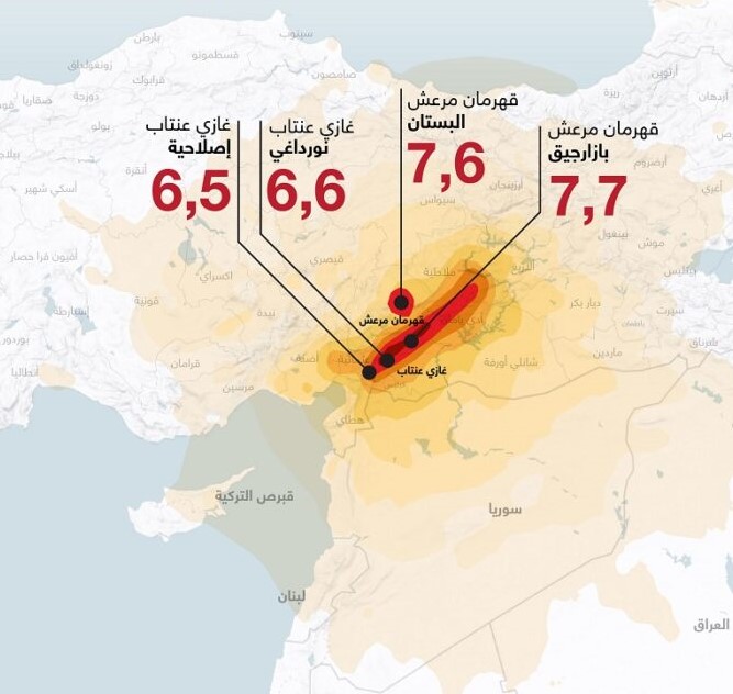
Map showing the epicenter of the 06/02/2023 earthquake, according to the Turkish Relief Agency – AFAD
The Effect of the Earthquake on Archaeological Sites:
The northwest region of Syria is one of the richest areas in the country in terms of archaeological sites and architectural monuments. The region contains hundreds of archaeological sites from the Roman and Byzantine periods, known as the “Dead Cities,” which feature well-preserved buildings made of large limestone blocks. Historically, earthquakes have significantly impacted the region over time, and are believed to have been one of the reasons these villages were abandoned in the 7th century AD. The area has experienced several devastating earthquakes, the most notable being the Aleppo earthquake of 1138 AD. However, the structural elements of these ancient cities are made of heavy stones, that have withstood the different waves of earthquakes and remained stable. Despite the numerous cracks in these stones, they do not pose any significant danger to visitors, except in some weak and unstable places.
Initial indicators suggest that the February 6 earthquake caused damage to these archaeological sites due to the severity of the quake, which registered a magnitude of 7.8 on the Richter scale. Furthermore, some of these ancient buildings were already affected during the ongoing war in Syria due to bombing, vandalism, secret digging. In addition to the occupation of these sites by displaced people modifying the historical buildings which has weekend them and mad them less resistant to natural forces.
Emergency Response Efforts:
Despite the state of shock after the earthquake due to the huge destruction and acute humanitarian crisis, it was important for us to react quickly regarding the affected archaeological sites. Thus, we suspended the protection work at the Ain Dara site and started an evaluation process for the affected archaeological sites. The emergency response plan was the result of a collaboration between SIMAT and the Idleb’s Antiquities Center which contributed voluntarily due to the lack of financial support to cover work expenses. The action plan included the following steps:
- Preliminary Survey of Archaeological Sites:
A preliminary survey was conducted in the northwest region of Syria through field visits to identify the damaged sites by the earthquake. Determining the earthquake’s impact was challenging due to existing damage from previous violations. We relied on information from locals and displaced persons living in or near the archaeological sites. In addition to analyzing the collapses in the walls, observing the surfaces of the collapsed stones, and ascertain the date of the collapse by measuring their position on the soil, since the earthquake occurred during rainy days, causing freshly collapsed stones to sink into the mud.
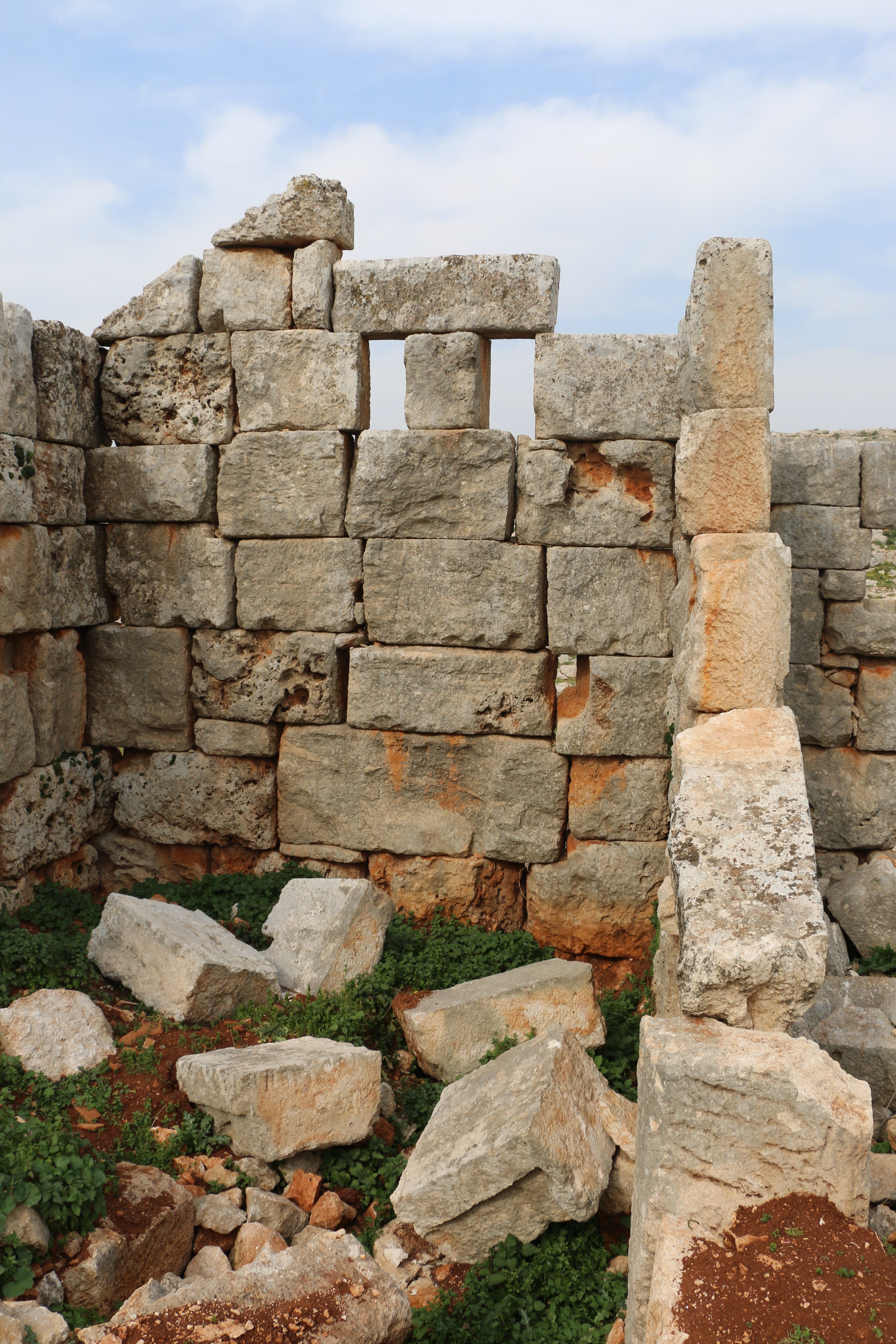
Collapse of an archaeological wall at the site of Khirbet al-Khatib, showing the stones being submerged in the surface layer of mud. © SIMAT
- Comparative Analysis:
Comparisons were made between the current state of certain important buildings and previously taken photos. This analysis revealed damage locations or confirmed the safety the buildings. For example, it confirmed that the Church of Qalb Lozeh had not suffered additional damage or cracks, despite rumors to the contrary
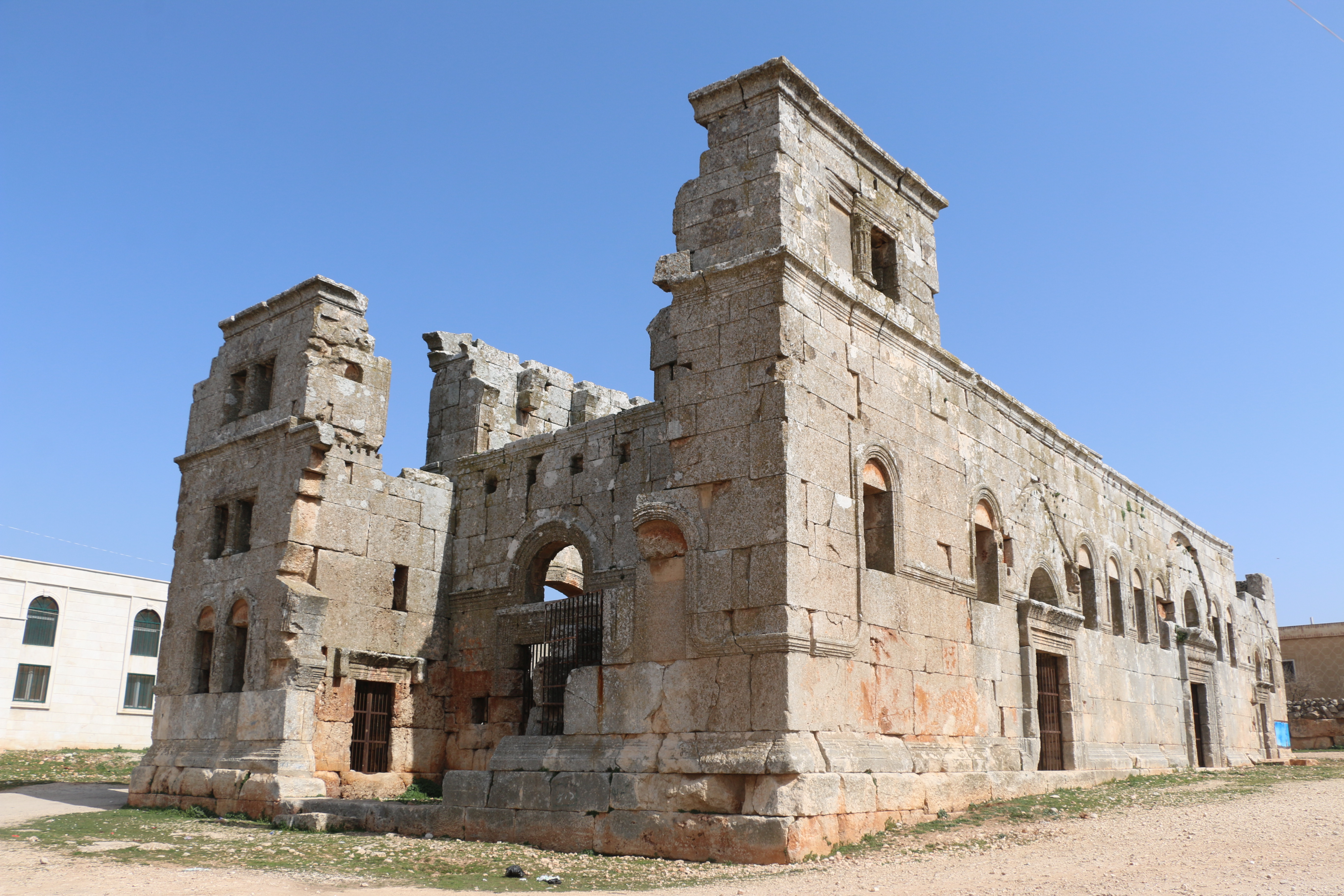
Qalb Lozeh Church – March 2023 © SIMAT
- Documentation and risk assessment cards were prepared for the damaged buildings.
- Evacuation Warnings:
Warnings were issued about the need to evacuate damaged sites that posed a danger to the surrounding population, particularly displaced persons. This was done in coordination with local councils and civil society organizations involved in providing shelters for earthquake victims.
- Action Plan and Emergency Interventions:
Preparing a study and an action plan of the damaged sites and buildings that requires urgent intervention to stabilize them and prevent further collapse.
Risks:
The initial survey of archaeological sites revealed the damage caused by the earthquake, which was more concentrated in sites that had been violated before the earthquake. It also highlighted the danger of parts of these buildings that cracked but did not collapse, which poses a great danger to the surrounding displaced population living in camps inside or near these sites.
These cracks might stabilize as other cracks have from successive historical earthquakes, so immediate intervention is necessary to study and document these cracks and ensure the stability of the buildings to either reassure the surrounding people or warn them from taking any measures that might harm those buildings. For example, a group of displaced people living in the archaeological site of Dair Kaita, a UNESCO World Heritage Site,

Dirqita archaeological site shows displaced people’s tents spread among the archaeological monuments © SIMAT
attempted to demolish a building damaged by the recent earthquake because they believed it posed a danger to the surrounding population, without considering the archaeological and historical significance of the building or checking its stability
The ancient building to be removed at the site of Dirqita for fear of its collapse as a result of the earthquake © SIMAT
However, our timely intervention prevented the demolition of the building and the administrative authority in the area was informed that damaged monuments may not be removed or demolished until the current state of safety of these sites has been assessed by specialized teams.
The most ssignificant Earthquake Damages:
The earthquake caused varying degrees of damage from one site to another, depending on the nature of each building and its proximity to the earthquake’s impact zone. The archaeological sites in Harim area were the most affected in terms of the spread and extent of the damage, including the Islamic Citadel of Harim, where parts of the walls, some ceilings, and arches collapsed, and numerous cracks appeared in the castle’s buildings

Collapse of parts of the walls of Harim Castle © SIMAT
The earthquake also left many gaps and holes in the ceilings of the castle buildings, which exposes people to the risk of falling through these deep gaps, some of which are up to 6 meters deep.
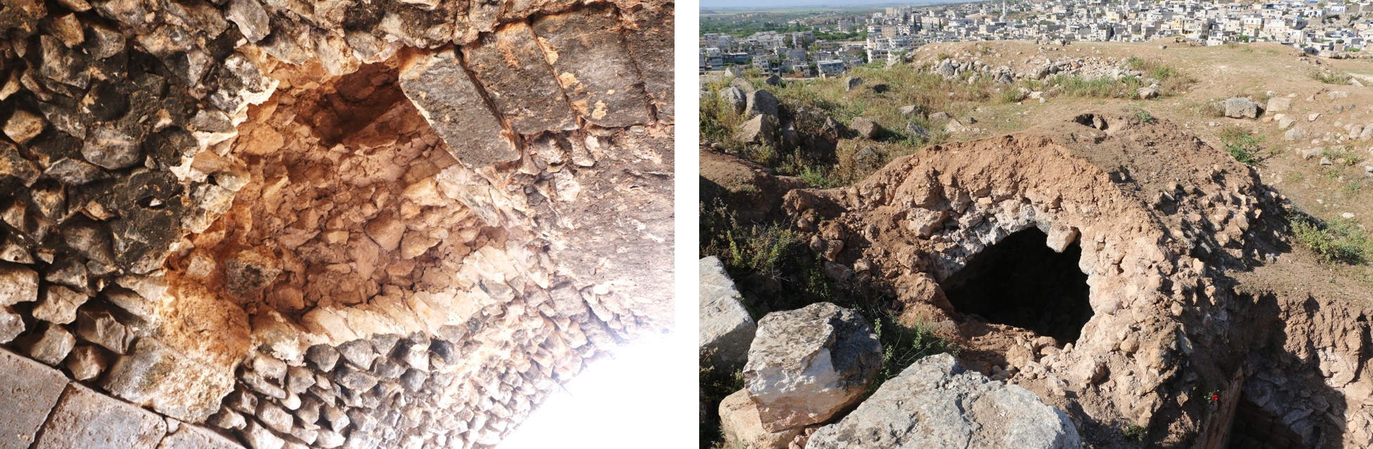
Collapses caused holes in the roofs of Harim Castle buildings © SIMAT
The archaeological sites in the limestone massif suffered varying degrees of damage, with the walls of some buildings collapsing, others cracking and some stones being displaced, as can be seen in the citadel of Sam’an, al-Bara, Baqirha, Dahis and other sites.

A collapsed archaeological wall at the site of Baqarha © SIMAT

Collapsed ancient buildings at Dahes site © SIMAT
Historic and archaeological buildings in the centers of Idlib, Harim, Ariha, Salqin, and Armanaz were also affected. Some of the historical mosque’s minarets was collapsed, such as the minaret of the Great Mosque of Ariha.
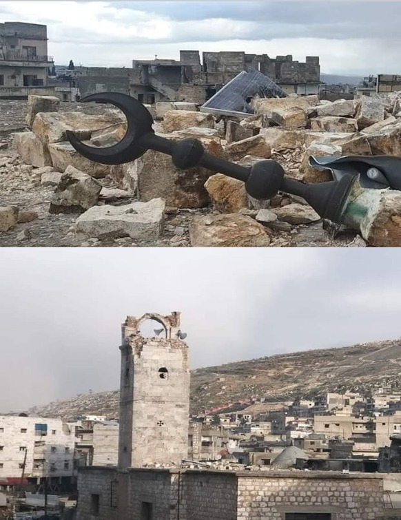
The collapse of the minaret of the Great Mosque of Jericho © Ayman Al-Nabou
Some historical houses were also damaged such as the Ghannoum House and the Fathi Ayashi House in Idlib, in addition to damage to the historical baths and archways.

Damage to the historic Ghanem House in the center of Idlib city © Idlib Antiquities Center
Another example is the Ain Dara site, where parts of the Iron Age temple were damaged, including the basalt carvings on the temple’s northern façade,
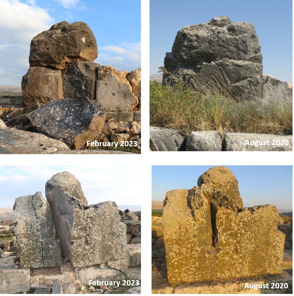
Damage to Ain Dara Temple sculptures as a result of the earthquake © SIMAT
which were already weakened by previous bombardments in 2018. There were also cracks and collapses in the hill itself, especially on the eastern side below the temple, possibly due to a stability problem caused by a road construction project on the hilltop in 2019, which posed a risk of the hill collapsing under the temple.
Recommendations:
Based on the post-earthquake situation and the identified risks and damages, we recommend prioritizing the following interventions measures due to their importance:
- Interventions in the Historical and Archaeological Buildings in City Centers:
These buildings are inhabited, posing risks to their residents if the current situation remains unchanged. Additionally, there are concerns that the residents might undertake improper demolition or restoration of the damaged parts.
- Intervention at Harim Citadel:
The collapse of parts of the walls and the retaining wall could cause damage to the residential buildings, as it is located on an elevated mound within the city center. It is also necessary to address the cracks and collapses inside the citadel to prevent further damage due to rainwater infiltration and other weather conditions. Additionally, the citadel is a major attraction for local visitors and school trips, where the gaps and wholes caused by the earthquake pose significant risks to children in particular.
- Intervention at Qal’at Sam’an:
Efforts should be made to preserve the rubble from the collapsed parts of the western basilica arch, one of the octagon sides surrounding St. Simeon’s pillar, due to the exceptional historical importance of this building. These stones should be preserved for future restoration and rebuilding of the facade and arch, as most of them remain intact and can be reused.
- Archaeological sites that include camps for displaced persons:
These sites need an assessment of their structural condition to either reassure the residents or warn them about the stability of these buildings, with emergency interventions to stabilize the fragile and cracked parts.
Conclusion:
We hope that this report and the data collected will help achieve a real response from donor organizations to address the disaster’s effects, especially non-governmental organizations, given the failure of international organizations, led by UNESCO, to provide any emergency support after the disaster.
We also hope that the administrative authorities and emergency response teams working in the area will refrain from taking negative actions at archaeological sites and coordinate with civil society organizations dedicated to heritage preservation to assess the current situation and take scientific steps to protect these buildings, especially historical buildings in city centers.
Finally, we argue that implementing protection projects for archaeological sites at this time will significantly help preserve these sites and enhance the work of local heritage preservation teams. In addition, protection projects are important for the local communities who seek the rehabilitation of their historical areas to feel safe around these historical sites.
Prepared by: Ammar Kannawi
July 1, 2023